
One of the most appealing aspects of the built environment by the waterfront is the riverfront walkway. Known formally as the Hudson River Waterfront Walkway, it is a 30 foot wide pathway by the river that runs from Bayonne to the George Washington Bridge. Public access to the waterfront is guaranteed under the Public Trust Doctrine which ensures in law the public’s right to use this valuable resource. In theory, it is available 24 hours a day for people to walk, jog and bike along its path. There are also opportunities for fishing, boating and kayaking in some locations.

While the walkway is a major public good providing space for recreation by the waterfront, its design and relationship to the built environment around it limits the public’s access to it and ability to enjoy it fully. By law the walkway must be at least 30 feet wide which limits the kinds of recreation that can take place and the amount of people that can use it at one time.

Most of the walkway is only wide enough to walk, bike or jog on. It is not wide enough for many other recreational activities people like to engage in by the water.

The towers that line the walkway create blank walls making the walkway a less lively and interesting space.
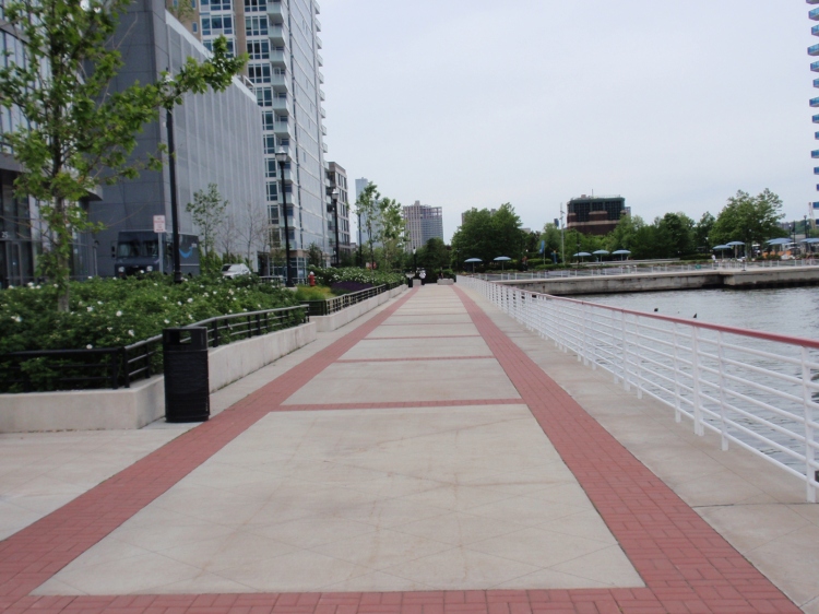
Because of the closeness of the high-rise buildings, the walkway is cast in shadow in many places, reducing the public’s enjoyment of it.

The discretion given to developers in the design and placement of their buildings along the walkway can be seen in the way it twists and turns becoming wider and narrower in parts making it difficult to navigate and enjoyable.
The proximity of hotel, office and apartment towers to the walkway raises questions about how the walkway and waterfront itself could have been designed differently with better results economically and socially for residents as well as developers.

One way to answer that question is by comparing Hoboken’s waterfront walkway to Jersey City’s.

In 1990, the Fund for a Better Waterfront (FBW), a citizen group focused on public access to the waterfront in Hoboken, began working on a plan to develop the waterfront. This plan, which was ultimately adopted by the city with some revisions, “mapped” the vacant land by the waterfront laying out public streets and the placement of blocks and lots on them. This map made clear what was public and private space and allowed the city to ensure that new development was in line with the character and scale of the rest of the city. Hoboken also created “as of right” zoning regulations prescribing the size, scale and kinds of buildings permitted. This avoided the need to negotiate with each developer on each proposal saving time and money for both parties.

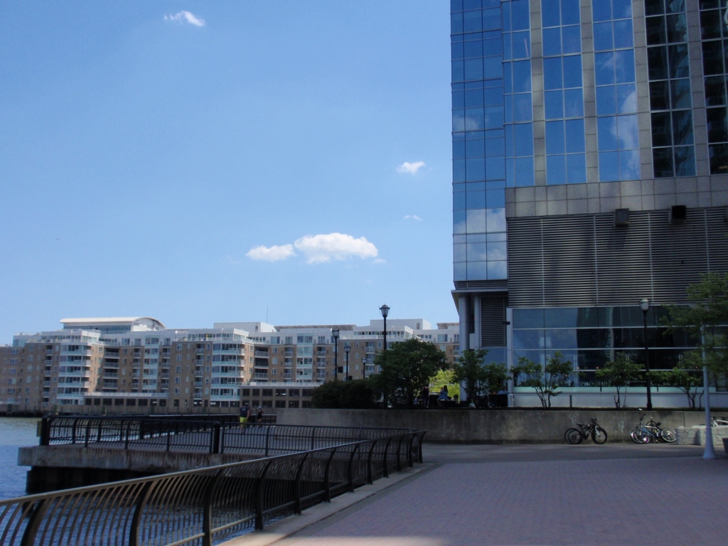
On Jersey City,’s waterfront as redevelopment began in the 1980’s, the process of mapping the waterfront before development took place did not occur according to FBW. Much of planning and design of the area was left to developers. As a result many of the streets do not link up with or follow the grid of the historic district next door. The towers built, with their large footprints, created superblocks making the waterfront less visible, inviting and accessible.

There are some streets, especially near the beginning of the walkway at its southern end, that connect with the street grid of the historic district. However, the office towers and their overwhelming presence along with the wide heavily trafficked cross street makes the waterfront less visible and accessible and blurs the distinction between private and public space.

Hoboken created a public street, Sinatra Drive, separating public space from private space by the waterfront. It is lined with stores, restaurants, offices and apartment buildings defining the line between public and private space. The street is also designed to be narrow to slow down traffic.

Jersey City’s waterfront walkway has no public street running parallel to it clearly separating public from private space.

In Hoboken, the buildings on its public street by the waterfront have front doors facing the street and the waterfront. This reinforces the public nature of this street.

In Jersey City, the riverfront walkway is lined with the backs of buildings, rear windows and other private spaces blurring the line between public and private space.

The “private property” sign on Jersey City’s walkway is necessitated because the distinction between public and private space is not apparent through the built environment itself.

Hoboken’s riverfront walkway has a significant amount of park space including a linear park running the length of its walkway.

Jersey City’s riverfront walkway has limited park space limiting recreational opportunities.

In contrast to Jersey City, Hoboken has a separate bike path running parallel to its walkway.

Unlike Jersey City, Hoboken has public restrooms along its walkway.

Hoboken’s waterfront demonstrates how local governments have the power to shape development in a way that benefits everyone. It shows how through mapping – laying out the blocks and streets of a parcel of land and through zoning regulations – cities can redevelop in more profitable and equitable ways. Most importantly, it illustrates the importance of community activists and public opinion in the redevelopment process. In 1990, after Hoboken approved a large redevelopment project by the waterfront, activists were able to have it put up for a vote by the public. The project was voted down by the public and, forming an organization, Fund for A Better Waterfront (FBW), these activists put forth their own plan to redevelop the waterfront which, with some changes, has been implemented over the years since.

The importance of community activism is not only highlighted by what happened in Hoboken, but what did not happen in Jersey City as well as other cities and towns along the Gold Coast. In 1995, FBW produced a report: Reclaiming the Waterfront: A Planning Guide for Waterfront Municipalities, and sent it to cities along the Gold Coast, including Jersey City, but none of the recommendations in it were adopted. This was a missed opportunity robbing residents of a vibrant waterfront park such as Hoboken has. According to FBW this loss was the result of the “privatization of planning” allowing developers too much leeway in the design and layouts of their projects. The question today is what can be done to make changes to Jersey City’s waterfront walkway today to make it a more inviting and enjoyable place for residents.
Get new content delivered directly to your inbox.
Follow This Blog
- Gentrification Math & the False Promise of Affordable Housing
- Why is the City Selling Public Property to Luxury Housing Developers?
- Why So Much Luxury Housing in a City Where Most Can’t Afford It?
- Why Do So Many New Apartment Houses Look Alike?
- Signs of Gentrification: House Numbers, Their Color and Design
